Data Input
The PyHelp module requires multiple weather and geomatics data to perform spatially distributed water balance calculations at the regional scale with the HELP infiltration model.
More specifically, weather data include precipitation, average air temperature, and global solar irradiance at a daily time step. Geomatics data consists in a uniformly spaced grid where the location coordinates must be defined for each cell of the grid, as well as the surface conditions required to compute evapotranspiration and runoff, and the soil and design data needed to compute infiltration, subrunoff, and groundwater recharge.
The input data must be formatted and saved in four coma-separated text files in the working directory of PyHelp with the following names:
precip_input_data.csvfor daily precipitation in mm
airtemp_input_data.csvfor average air temperature in °C
solrad_input_data.csvfor global solar irradiance in MJ/m²
input_grid.csvfor the grid and geomatics data.
This section presents how to prepare these input data files, either manually or automatically with the tools that are available in PyHelp.
Format of the weather input data
Daily precipitation data, average air temperature and global solar irradiance
are needed by PyHelp to calculate the water balance for each cell of the grid
with the HELP model.
Data from any sources can be used, as long as the data are correctly formatted
and saved in the working directory as coma-separated text files named as
precip_input_data.csv for daily precipitation,
airtemp_input_data.csv for average air temperature, and
solrad_input_data.csv for global solar irradiance.
An example of correctly formatted input weather data file is shown in Fig. 1. The first column of the data is used to store the dates in a dd/mm/yyyy format. Additional columns are used to store the data of the daily meteorological time series for one or more geographic locations. At least one daily time series is required. When more than one time series is available, PyHelp takes the time series closest to each cell of the grid to do the calculations. The latitude and longitude coordinates, in decimal degree, must be provided for each time series in the header of the file. All other information in the header is optional and does not need to be included in the input file.
The data must be saved as text using the coma (,) as separator and the dot (.) as decimal symbol. Saving the data using the utf8 encoding is strongly recommended. The input weather data must be saved in the International System of Units (SI). More specifically, daily precipitation must be saved in mm, average air temperature in °C, and global solar irradiance in MJ/m².
By default, the weather data are automatically loaded when instantiating the
HelpManager class or when setting the working directory
with set_workdir(). It is also possible to
explicitly force a reload of the weather data from the input data files
with the load_weather_input_data() method of the
HelpManager class.
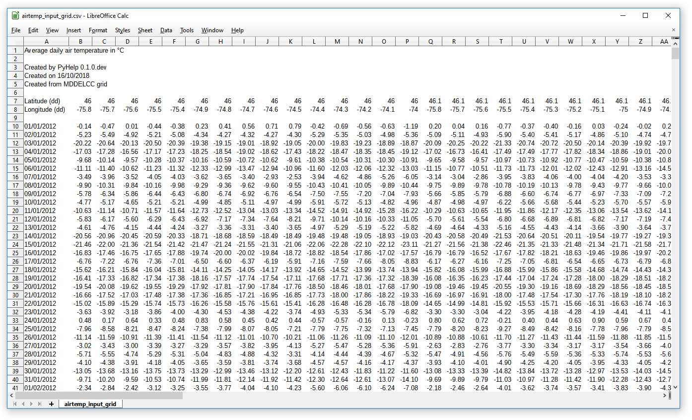
Fig. 1 Example of a correctly formatted input weather data file.
Format of the grid input data
The geomatics data required to run HELP calculations for each cell of
the grid must be formatted and saved in the working directory as a
coma-separated text file named grid_input.csv.
An example of correctly formatted input grid data file is shown in
Fig. 2 and Table 1 presents
the required information that must be provided for each cell of the grid in
the input grid data file.
Note that the name of the fields must be respected faithfully in the data
header of the file grid_input.csv, as well as the units of
the data.
The field run is used to identify cells that must be run with HELP. All
cells with a run value of 0 are skipped when executing
pyhelp.HelpManager.calc_help_cells(). Moreover, the method
pyhelp.HelpManager.get_run_cellnames() can be used to get a list of cell
ids for wich the run value is 1.
The field context is used to identify cells that are consisered to be
located in surface water bodies. This field is also used to identify cells
that are located near a stream, in urban areas, and cells for which data are
incomplete.
In addition, any field can be added to the grid for cell selection purpose. For example, a field could be added to faciliate the selection of cells by watershed or region. These selection fields are particularly useful for the calibration of the model.
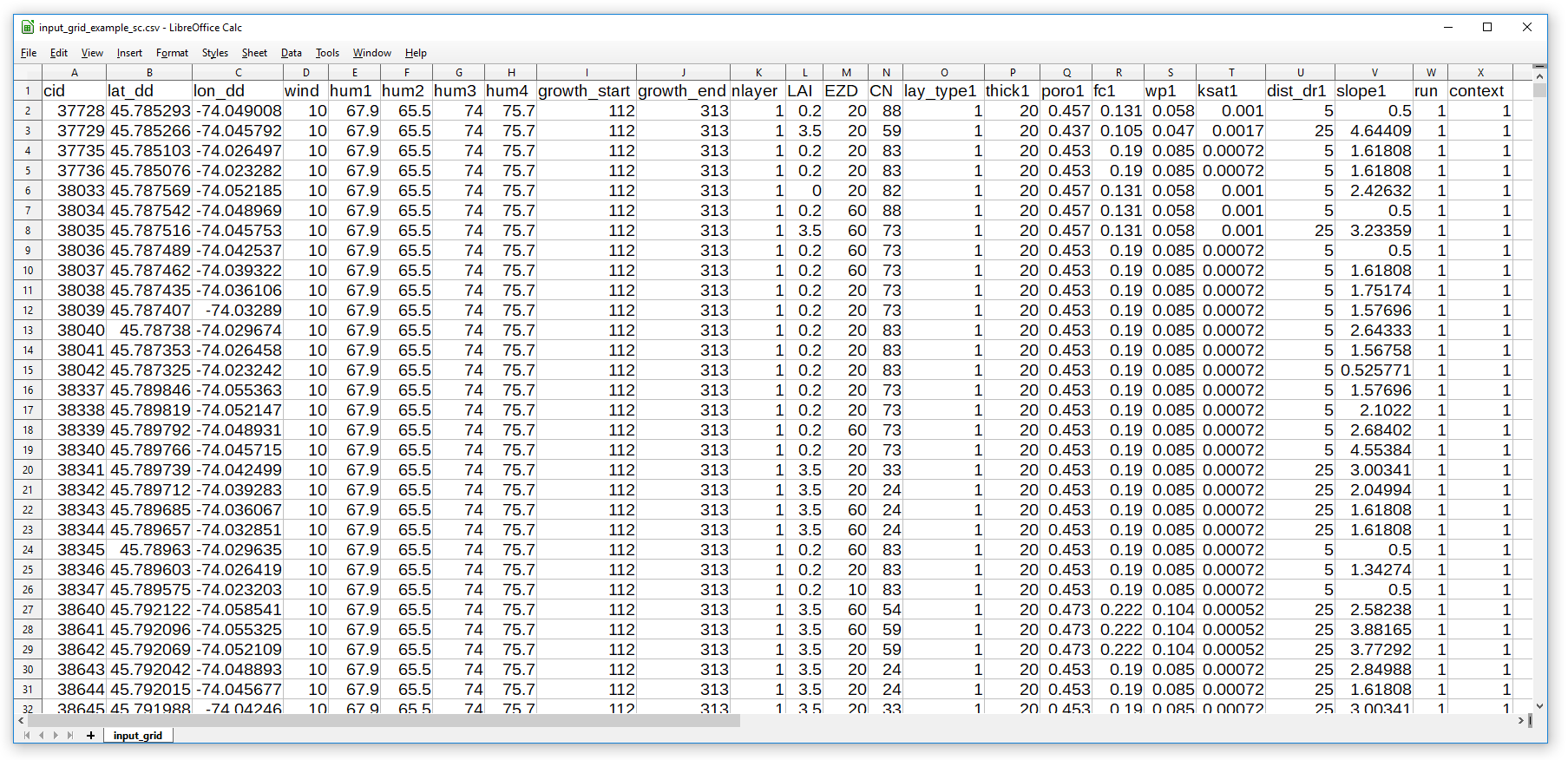
Fig. 2 Example of a correctly formatted grid input data file.
| Field Name | Units | Description |
|---|---|---|
| cid | Unique cell ID | |
| lat_dd | Decimal degrees | Latitude of the cell centroid |
| lon_dd | Decimal degrees | Longitude of the cell centroid |
| wind | km/h | Average annual wind speed |
| hum1 | % | Average quaterly relative humidity (jan to mar) |
| hum2 | % | Average quaterly relative humidity (apr to jun) |
| hum3 | % | Average quaterly relative humidity (jul to sep) |
| hum4 | % | Average quaterly relative humidity (oct to dec) |
| growth_start | Julian day | First day of the growing season |
| growth_end | Julian day | Last day of the growing season |
| LAI | Maximum leaf area index | |
| EZD | cm | Evaporative zone depth |
| CN | Curve Number | |
| nlayer | Number of hydrostratigraphic layers in the soil profile at cell cid | |
| lay_type{i} | Type of HELP layer of the ith soil layer | |
| thick{i} | cm | Thickness of the ith soil layer |
| poro{i} | m³/m³ | Total porosity of the ith soil layer |
| fc{i} | m³/m³ | Field capacity of the ith soil layer |
| wp{i} | m³/m³ | Wilting point of the ith soil layer |
| ksat | cm/s | Saturated hydraulic conductivity of the ith soil layer |
| dist_dr | m | Distance to discharge |
| slope | % | Average slope |
| run | Identify cells that need to be run with the HELP model | |
| context | Identify cells by context ( 0 - Water cell, 1 - Normal cell, 2 - Stream edge cell with superficial hypodermic runoff, 3 - River edge cell with deep hypodermic runoff, 4 - Urban cell, 5 - Cell not mapped) |